Puente Nuevo
Puente Nuevo, Ronda's 'new bridge' was completed in 1793, after 40 years in construction and after the loss of the lives of 50 builders constructing the span bridging the 98m Tajo gorge. The bridge bisects Ronda into new town (mercadillo, 'little market') and old (La Ciudad). The project was first proposed by King Felipe V in 1735, to improve an earlier and impossibly steep 16th century bridge, the Puente Viejo, located 150m upstream from this Puente Nuevo and 50m further the 12th century Moorish bridge by the old Baños de los Arabes (Arab baths).
 |
| 'Puente Nuevo' spanning the gorge in Ronda. |
Parts of the Puente Viejo solid span column interiors were used as a prison and, later, as a bar, but are now a museum dedicated to the old prison and bridge. Both sides of the Civil War used the prison as a torture chamber for opposition captives, who it is said were sometimes dispatched from the balconied windows to the rocks below, although this is disputed as myth by some.
 |
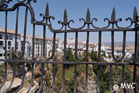
| The majestic town of Ronda retains much of its historic charm. |
Many Moorish towns and villages were abandoned after the Christians reconquest, however Ronda was always too important for that. Its unsurpassed strategic advantages had attracted the dominant forces in the Peninsula since before Rome had an empire. Moorish buildings that had remained intact and appeared likely to stay that way barring deliberate demolition were simply commandeered and adapted by the incoming Christians.
As the dust settled, Ronda became a magnet for itinerant merchants, anxious for somewhere to show and sell their wares. So numerous did they become, that space within the town walls was soon at a premium. To ease the situation, a tax was imposed on traders operating inside the city. Predictably, this drove them to set up their stalls and tents outside the gates. Thus, the districts of Barrio de San Francisco and el Mercadillo were born - the former in front of the Puerta Almocábar and the latter close to the existing bridge across the gorge, then merely el puente, now known as Puente Viejo.
By the 18th Century, el Mercadillo, the "little market", had long outgrown its homely nickname. It was the living heart of a thriving modern town, and its main street, calle Real, was the commercial centre for the entire Ronda region.
The sheer numbers of people crossing el puente to reach the market became unsustainable. In any case, when the river was in spate it was regularly flooded. It was clear that there needed to be a new bridge to replace it, a puente nuevo beyond the reach of the waters.
Step forward José Martin de Aldehuela. It is this remarkable architect's magnificent masterpiece that spans el tajo today, at a breath-taking height of over 300 feet. Standing on its walls and staring directly into the gorge below is not for acrophobics. But for all his genius, his plans would have remained nothing but lines scratched onto a yellowing page without the real builders; the anonymous hundreds who worked and the unsung dozens who died to put the bricks and mortar into place. Their leader was a man, born in Ronda, who was in his way as remarkable as de Aldehuela himself. Juan Antonio Díaz Machuca, faced with the formidable problem of taking a concept and turning it into a bridge, designed a set of revolutionary machines to raise the huge stone blocks from the bottom of the gorge.
 |
|
View from Puente Nuevo in Ronda
|
This was not the first attempt to build such a bridge. Records disagree on the actual dates, but in the early 1730s, one was knocked together in just eight months by Juan Camacho and José Garcia. If the pair wore hats, they were probably stetsons, for they must surely have been the prototypes of today's cowboy builders. Their hastily constructed and nail-bitingly perilous structure survived for only six years before collapsing with the loss of around fifty lives.
Building of the replacement commenced in 1751, on the very foundations of Camacho and Garcia's slapdash disaster. With that fiasco very much in mind, José Martin de Aldehuela was determined that his bridge would be built to last.
Construction took 42 years, and the Puente Nuevo was finally ready for use in 1793. It is built of solid blocks of stone in a series of arches. Beneath the central arch is a chamber that in time became used, among other things, as a prison. It is entered via a square building which was once the guard-house. For a fee of a few euro, visitors can enter the chamber and see an exhibition describing the bridge's history and construction.
Opening Hours: Mon to Friday 10.00-18.00 (19.00 Spring and Summer), Saturday 10.00-13.45 and 15.00-18.00, Sunday 10.00-15.00. Tel: 620 340 148. Admission ¡3 Euro.
A curious legend grew up around José Martin de Aldehuela. It was said that shortly after the completion of the bridge he fell from it to his death in the gorge below. Doubtless there were those who whispered "murder", but the two most popular theories were that he committed suicide, having decided that with the completion of his great masterpiece his work on Earth was done, or that he simply slipped and fell while carrying out an inspection. In fact, none of these is true. He died in Málaga from natural causes in 1802.
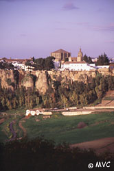 |
| Ronda general view springtime |
The very existence of a bridge at such a height inevitably attracts the darker side of human nature, whether that results in suicide, murder, or summary execution. All have been common throughout the history of Puente Nuevo. There can be little doubt that many a captive fell, or was pushed to his death from the prison beneath the central arch. Suicides and accidents remain common - the latter often resulting from ill-advised attempts to lean over that extra inch to take a spectacular photograph of the valley below. The occasional but sad task of recovering such souls requires a very large crane to be parked on the bridge itself.
For a classic and truly astounding view of the bridge from below, take the small tourist bus which operates an hourly service from outside the parador. Passengers are taken not only into the valley to view the bridge, but also through many of the more famous streets of the old town. The fare is currently 10 Euros per person, and although the driver speaks only Spanish, an explanatory video, shown throughout the journey, is available in English. The unamed waterfall seen here is a 26m drop and actually one of the highest in Andalucia a cool video featuring the waterfall can be viewed on our Ronda Videos page.
Location
Calle Armiñán, adjacent to Plaza Espana