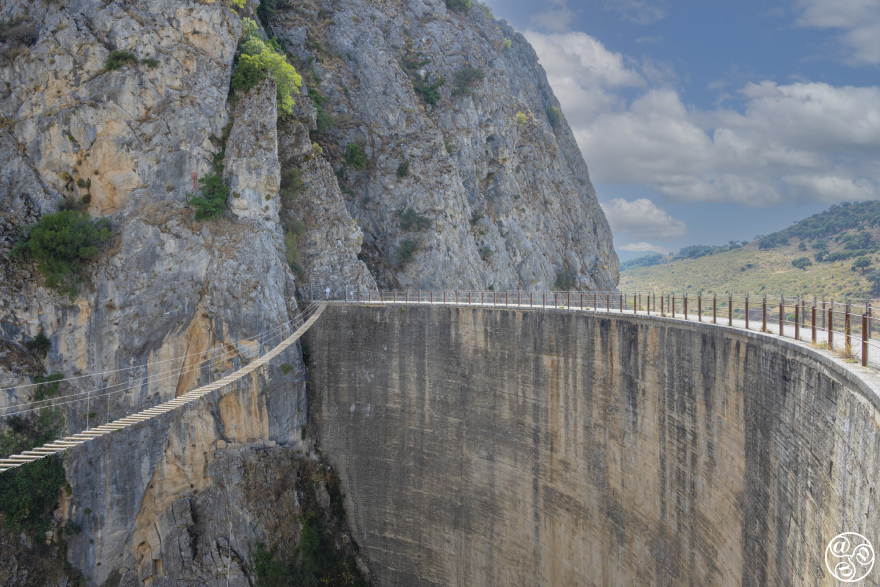
 The Presa de los Caballeros (Dam) forms the Embalse de Montejaque (Montejaque reservoir) © Chris Chaplow
Things to see near Montejaque
There are plenty of things to see near Montejaque. This attractions and curiosities do require you to have you own transport or hire car.
Embalse de Montejaque, Presa de los Caballeros and Cueva de Hundidero
Driving to Montejaque from the Montecorto side and leaving the A-374 (Ronda to Seville) road to join the MA-8402 by the Venta La Vega, straight away the road crosses over the medieval bridge over the small river Canada del Cupil. This ravine once served an old cattle way that ran from Ronda to Seville. A Moorish lookout tower once stood on the hill above, but little of the tower remains today.
The MA-8402 winds and climbs up and following a steep curve left, looking to the below right is an impressive site; a large dam with an empty reservoir. Though some water collects in the winter. The Rio Guaduares collects mountain water during the winter months and the river disappears at this point into a cave.
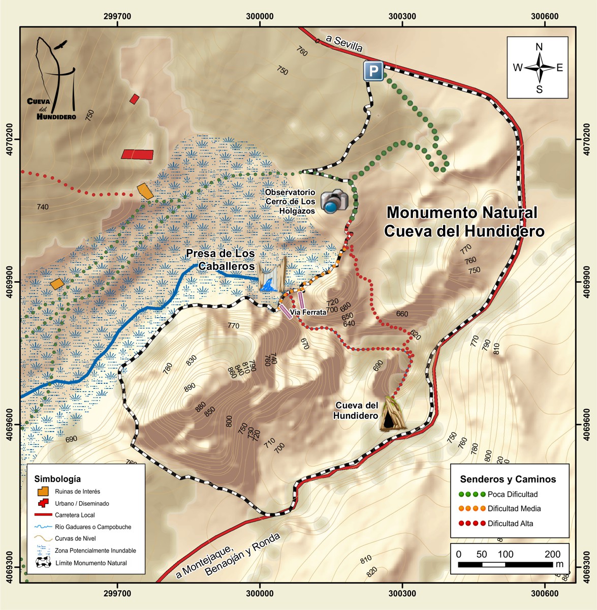
The wider area between the mouth of the Hundidero Cave and the Presa de los Caballeros is classified as a Natural Monument of Andalucia. Useful plan.
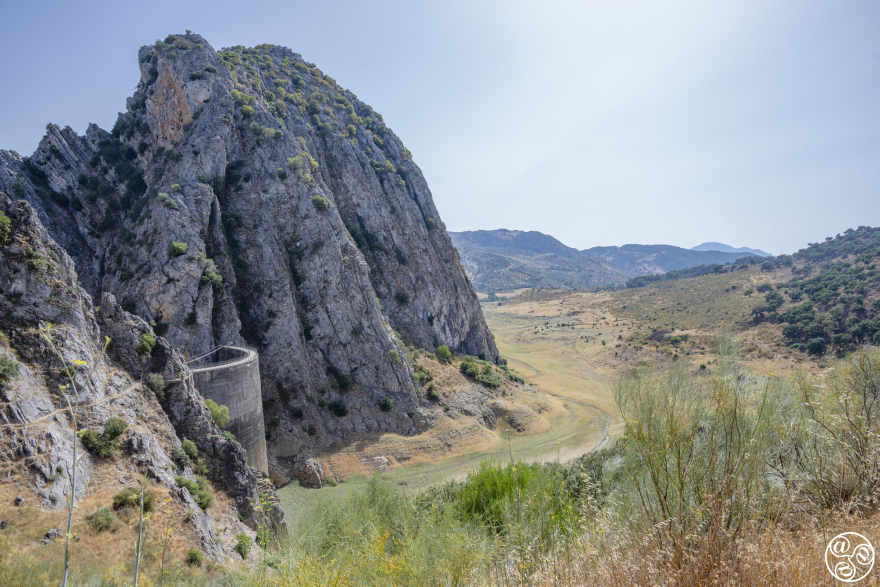 Embalse de Montejaque (Montejaque reservoir) © Chris Chaplow
The natural water flow through the cave system was changed dramatically and unpredictably in 1920's with the construction of one of the first horseshoe shaped concrete wall dams in Spain. The Presa de los Caballeros (Dam) forms the Embalse de Montejaque (Montejaque reservoir) on the Rio Guaduares just upstream of the Cueva del Hundidero entrance. The dam was competed in 1927 but reservoir never fills due to seepage of water into the limestone rocks. The water reappeared inside the Hunidero-Gata cave system. Walkways, bridges and lighting were installed, some of which can still be seen by cavers today, to facilitate workers access for sealing openings with concrete. These construction workers were probably the first humans to fully traverse the 8 km route between the two caves. The water sealing was without success and in the and early 1930's many international experts offered solutions. The Civil War stopped the project which was officially declared abandoned in 1944, the very year that the reservoir water reached 12m from the top of the dam. The Civil Engineer's case study dam can be clearly seen today from the MA-8403. It is possible to visit the dam and walk across for that special selfie to challenge those at Caminito del Rey A Tibetan style hanging walkway was constructed in 2024 across the face of the dam as part of the Via Ferrata (only for use with guides). Other visitors explore the reservoir bed which is usually dry. To reach the Cueva del Gato (Cat Cave) from Presa de los Caballeros it is necessary to drive 10 km around the mountain via Montejaque and Benaojan.
How to walk to the Dam: This impressive feat of engineering makes for an interesting 1-2 hr walk. Driving towards Montejaque village, there is a car park on the right-hand side (west side) at about km 3.5, with a wooden information kiosk and some information boards. Park here and bring water with you for the 1 km downhill walk ahead. Take the 'Sendero a la Presa de Montejaque' path (Path to the Montejaque Dam) by the car park entrance. Follow the path down through the cutting for about 600 metres. Follow the horseshoe bend round to the right. After another 200 metres, follow the main track to the right where it ends in a widening. Take the small footpath down the hill and cross the 'bridge', which is actually a sluice outlet for the reservoir. Continue along the path until you reach the impressive concrete dam. You can walk over the top of the dam to the other side. You will notice that the reservoir is empty.
The top of the dam is a great place to take photographs. From there, you can see the Tibetan hanging footbridge strung across the front of the dam. If you would like to cross the gorge on this bridge, contact one of the adventure sports companies for guidance.
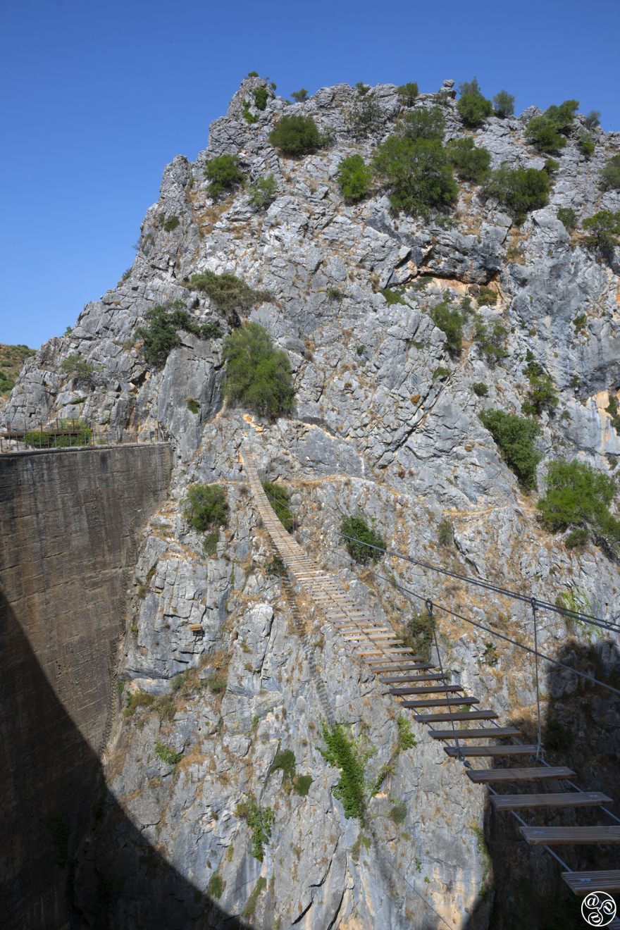 Tibetan walkway and The Presa de los Caballeros (Dam) © Chris Chaplow
From here you can take the more difficult track to Cueva de Hundidero, which eventually connects to Cueva del Gato on the other side of the mountainnear Benaoján. Permits are required to enter the system, which sometimes involves swimming underwater. The water exits the mountain down by the railway line at El Gato (visible from the train and road). A number of hapless explorers have drowned in this system, due to unpredictable water levels, and it is not recommended to the novice. This cave is home to one of the largest sedentary colonies of cave bats. It is more than fifty meters high in places. Can only be visited with guide and permissions. If you would like to enter Cueva de Hundidero, contact one of the adventure sports companies for guidance. Otherwise just take the time to walk the steep stairs down to the Hundidero Cave entrance which is just below the road.
You can only take a few steps inside Cueva de Hundidero and it gets dark quickly. Below is a video made by the Ubrique mountain rescue team showing the complicated 4km traverse from Hundidero Cave to the Cat Cave. Turn down the volume if the music is not to your taste.
As a footnote, the winter rains in January 2026 were so severe that the Embalse de Montejaque reservoir became full, putting unusual pressure on the Presa de los Caballeros dam. All the sluice gates were fully opened, creating a spectacular waterfall, and there was some concern for a while. However, the old dam stood firm, and the water levels subsided. In the video below one can the the full reservoir and the release of water. Below is a video of the water being released when the sluice gates were fully opened.
Dolmen El Gigante - Neolithic burial chamber
Dolmen de la Giganta
The Dolmen de la Giganta, also known as the Dolmen of Cortijo del Chopo, is a megalithic structure dating from the late Neolithic to the early Copper Age. It is a gallery-corridor type dolmen, featuring an entrance that leads to a burial chamber where bones were deposited. It is located on the road from Ronda to Algodonales, near the junction for Grazalema. It can be reached on foot from the A-372. Discovered in 1941, it is situated on private property. Location Lat 36.78375 Long -5.271384514
It is often pictured as a fine example of a Neolithic burial chamber. Its location remained a secret to tourists for many years, but thanks to Google Maps, it is difficult to keep it secret now. The locations of the other 14 dolmens in the area have always been public knowledge.
Shrine to a bus accident
The next kilometre of road to Montejaque hugs a cliff. Take care, as the road is narrow and winding, and oncoming cars may cross the centre line. As you curve steeply downhill with a drop on your right, you will see a curious red lamp. This lamp marks the site of a horrific accident that occurred on 27 April 1966, when a coach with three teachers and 47 pupils went over the edge of the cliff and rolled 50 metres down the ravine, killing the driver, who was also the father of one of the pupils; four sixth-grade boys and two teachers, the History teacher María Victoria Serrano and the Greek teacher Francisco López. The day before Fransico had asked to take the place of another teacher as was interested to visit the Serrania de Ronda for the first time. It had been a school trip from Victoria Secondary School in the Martiricos district of Málaga city to Cueva de la Pileta. A memorial now marks the spot where flowers are often laid on the anniversary of the accident.
The Valley of the Republicans
The Llanos de los Republicanos (Plains of the Republicans) are a 'hidden valley' between Montejaque and Villaluenga del Rosario, divided by the border between the provinces of Málaga and Cádiz. When the villages fell to the Nationalist forces in 1937, Republicans took refuge in the large, fertile valley surrounded by mountain ridges that is known today as the Valley of the Republicans. Read more on the Montejaque History page.
To reach the valley, leave Montejaque via Calle Dr Vazquez y Guiterrez, walk past the Fuente Abrevado, then take the track continuing southwest into the Llano de Libar (36.669863, -5.331287). From there, find a route to cross the mountain ridge to the right, over to the area near the Sima del Republicano, at around 36.6816723, -5.3434. You will pass an outcrop where a number of griffon vultures live during the summer. Climbing to the top of the ridge offers views of bandit country and the Grazalema Natural Park. It's easy to see why this place was chosen. You can then drop down the west side into Llanos del Republicano, which is closer to Villaluenga del Rosario. Alternatively, stay on the high ridge and look for the mountain refuge called Refugio del Correo, located at coordinates 36.6671, -5.35147. Then, return back the same way, descending the east side of the ridge to the Llanos de Libar, and continuing north-west back to Montejaque.
It's actually easier to reach Llanos del Republicano from Villaluenga del Rosario. From the A-374, drive south along Calle Albarrada as far as the Puerto de las Viñas pass (36.6904209, -5.37201386), where you will find a small car park by the farmstead. Then, continue on foot, following the path down into the plain. Google Maps records a central point in the plain as 36.681697, -5.35689.