 Cathedral of the Serrania
Alpandeire Home | History | Things To See | Fray Leopoldo
Things to see in Alpandeire
The Jesuit twin towered Church of San Antonio de Padua is the most striking landmark when approaching Alpandeire. Known locally as the 'Cathedral of the Serrania' due to its size, it was begun by the Bishop of Seville, Diego de Deza, in 1505. What inspired such a large church is not known, but it was not completed until the end of the 18th century, when it was fully restored. The main nave is flanked by two later restoration projects of 1968. The twin towers are octagonal and the church is mainly built of brick. The font is of blue marble brought from Trinidad in the 19th century and a 18th century statue to local saint San Roque, whose feast is celebrated every 16-18 August, can be seen. The silver used for communion is of exceptional quality.
Under the church there is a crypt full of local legend, mainly due to two mummies. They are thought to be a married couple who donated a large sum of money to have the church completed. The locals say that other bodies deposited there later remain almost perfectly embalmed despite the passing of time.
Other than the birthplace of Fray Leopoldo, the other most interesting house in the village is the Antiguo Posito. Built in the 17th century, it currently houses Alpandeire's cultural centre. The Monolith of Ferdinando VII can be seen.
El Pozancon & El Chorreon
South east of the village, 200m from the nearest house, a large spring, known locally as the Alfaguaras, rises after heavy rain. Many subterranean rivers exist in this limestone region, and this is often mistaken as the 'source' of the Genal. It's an idyllic place to stop on the edge of the village. About a kilometre from the village is an even more spectacular 50 metre high waterfall, best seen outside high summer when the source dwindles.
 |
| Fray Leopoldo. |
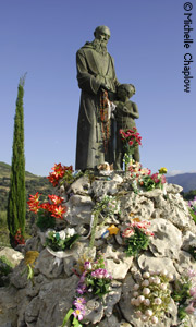
In Search of Fray Leopoldo
There are three Fray Leopoldo monuments in the vicinity.
His birthplace can be seen in the centre of the village.
On the way to Ronda, roughly three kilometres out of the village, a signpost on the left identifies Villa Fria. This is where he spent most of his early days, before he left the village at the age of 33.
On the Farajan other side of the village at a place known as El Cerrajon, a statue was raised in his honour.
Los Castillejos
As place name evidence suggests, this was the site of a Moorish fortification. However, it is also an interesting limestone outcrop in its own right. The formation has an impressive tajo, or cliff, with a cave beneath it.
Cortijo de los Casarones (Audalaza)
This is the site of an interesting deserted Moorish village with some definite remains still visible, 450 years after the pueblo was cleared. It was a prosperous community and was the centre for silk production in the whole of the Ronda region. Indeed the area today is known as the Huerta de la Seda (silk). During the Arabic period it was called Guir Alhachara (the cave of the piedras, rocks) and was corrupted to Audalaza and later, after the Reconquest, to Guidazara.
At the time of the conquest in 1485, the Moorish under-landlord was recorded as Juan Ozmin de Audazar. The records also mention a Jewish population and single out one, Salamon Aben Elfa, for special mention. He was very much involved in the silk industry, an economic trade developed by the Jews when society had pushed them into marginal economies. By the time the pueblo had been conquered, Jews were already being expelled from dioceses in Seville, Cordoba and Cadiz. As Malaga had yet to fall, it is only logical to say that all Jews in the newly conquered territories in the Ronda area were immediately persecuted. This may explain the sudden fall in population from 59 households (pop. 200) in the census of 1492, to only 12 heads of houses in 1500.
The rapid fall in population robbed Audaluza of the chance of becoming an independent parish and it was swallowed by nearby Atajate. The register of 1557-59 does not mention the size of the population, and it can be presumed that by this time it was deserted. Certainly, after the revolt of 1570, no one was left and, along with the deserted settlement of Pospitar, the territory was annexed by the pueblo of Alpandeire in 1572.
Located on the track that links Atajate to Alpandeire, its site lies in a fertile valley fed by numerous streams. The well-watered stream of Arroyo de Audaza is the only remaining sign of its existence. En route to the semi-ruined finca of Cortijo de los Casarones near the conjunction of the rivers Laza and Audaza, the site of the village is behind the farmstead at the bottom of the slope, 650 metres above sea level. Excavations between 1995-6 suggested that the small mosque was converted to a Christian chapel and the excavated cemetery confirms that three religious groups used it at various times. The remaining evidence of habitation is the water channel that brought water from the river to drive at least one mill.
Dolmenes de las Encinas Borrachas
The most accessible dolmens can be found by driving out of Ronda to the junction of the local road that leads down to the village. Keep on the Atajate road and after two kilometres you reach a large bend. A sign identifies Puerto Encinas Borrachas, 1,000 metres above sea level. To the right, by an old finca, is a flat piece of land. An old semicobbled road leads 100 metres to a low line of standing stones, the burial dolmens.
It is on private land, but the old trackway that incidentally used to be the original road to Ronda is a public right of way (Real Canáda). Even though a sign indicates that this is a private hunting ground, go through (and close!) the gate and follow the road to the stones. They are not as impressive as other dolmens in the area but are worth a look. Erosion and ploughing have destroyed most of this site, almost certainly occurring during the late Moorish period, when flat land was at a premium.
This is a singled chambered corridor dolmen aligned NW-SE. Just over 6.5 metres in length, its passage may have led into a galleried burial pit. The stones would have been capped by slabs and the whole chamber would have been covered by a gentle sloping mound.
The old track leading north led onto Ronda was almost certainly a Roman road, as it meets a medieval pathway when it drops down into a gorge (Tajo del Abanico, Ronda).
Jarastepar
The highest point in the district, the peak of Jarastepar is 1,421m above sea level. On clear days the whole coast is visible, stretching as far as Gibraltar. The area has many peaks and cliffs.