The Caminito del Rey, The King´s path. The old and the new pathways |
|
DETAILED DISCRIPTION OF THE ROUTE
By Chris Chaplow and photos by Michelle Chaplow and Kevin George Monterrubio
OFICIAL ACCESS PATH
The official starting point of the Camino de Rey 2.5 km access path is on the country road MA-444 just south where it crosses over the Conde de Guadalhorce Dam by the Sillon del Rey (King's seat) a stone seat where King Alfonso XIII signed off the dam in 1926.
Nearby is near a popular roadside restaurant called "El Kiosko". (GPS 36.931863, -4.801762) you can join the same main access path; walk through the little tunnel just to the right of the El Kiosko restaurant and on leaving the tunnel, take the path immediately to the right which is signposted "Camino del Rey 2.7 km".

Follow this path through the Aleppo pine trees which were planted to stabilize the ground and reduce silt flowing into the reservoir. It climbs up to the ridge, then take a sign-posted "Camino de Rey 1.8km" right turn to drop down and walk alongside the 4600m3 capacity Gaitanejo reservoir on your left. You can see evidence of the flood of October 2018 in various places.
On the other side of the reservoir look out for the exposed sandstone cliff face with strange erosions. These are 'tafoni', cave-like formations, created when clay is compressed by big blocks of sandstone by water or wind. The cliff is called Arco Gothico (Gothic Arch) although the shape of the arch is semi-circular not gothic.
At the end of this path climb a few steps to the access road where you will find the information office for registration and collection of safety hats. Allow 30 to 50 minutes for this access path walk.
SHORTER ACCESS ROAD
A shorter alternative access road (not path) has become more popular, it leaves the MA-444 just south of the small tunnel on the MA-444 near the restaurant El Mirador de Ardales (900m south of El Kiosko on the MA-444). As an easier and quicker alternative to the official access path you can park around this junction ( GPS 36.927564 -4.801131) and walk along the access road instead of the access path to the Camino del Rey information office.
Allow 25 minutes for this access road walk.
Gaitanejo Reservoir
Once you begin the walk you pass the old Gaitanejo Hydroelectric Power Station built in 1927 it is one of the oldest in Spain. The Substation is interestingly ornate building on the right. It is constructed with different colours of rough stone and features are decorated with white limestone contrasting with the green woodwork. On the left is the Gaitanejo Dam, also built in 1927 by Rafael Benjumea. It is 20 m high and 55 m long, today the reservoir is only used for water storage and not hydro-electricity generation. The name Gaitanes or Gaitano refers to bearded vultures which can often be seen overhead.
Across on the other side of the river, cave houses can be seen in the Parda Mountains. These were homes to the workers of the hydroelectric complex.
The path goes down some steps and along the oipen valley towards the entrance of the Gaitanejo Gorge where are the ruins of the small Cambutas Dam and the inlet of the long aqueduct canal that the Caminito del Rey path follows along the walk.
The old Chorro Dam can also be seen near the entrance to the Gorge. This is where the 1904 power station was located before it was replaced by the Gaitanejo Dam Power Station.
On the other side of the river are some commemorative plaques that mark the water level reached during several historic river floods on 2nd August 1941 and 27th September 1949.
GAITENEJO GORGE
The entrance into Gaitanejo Gorge starts with a small round viewpoint. There are two plaques here an original one from 1921 in memory of Rafael Benjumea y Burín, Count of Guadalhorce, who lead the project. Above it a more recent plaque from the 2015 renovation, notice it has wrong date. Read in the history section why how the opening was delayed.
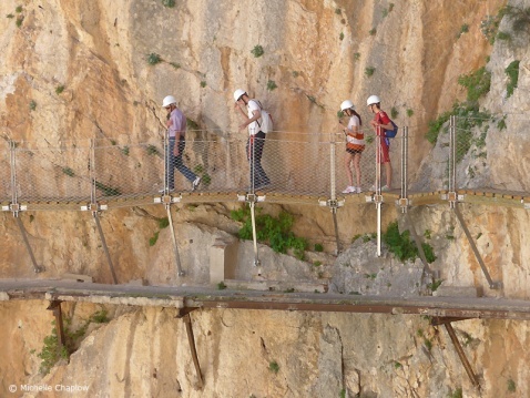
Remember there are tree boardwalks dating 1907, 1927, 2015. The first boardwalk was constructed from iron rods, anchored in the rock to support horizontal struts on which long planks where placed. The horizontal struts were also tied in by rope fixed from above that which also served as a handrail. This boardwalk only existed only in the Gaitanejo Gorge and was only for the station workers.

In the 1927 path steel railway lines were conveniently used to span lengthways between the supports. Concrete slabs were laid across between the lower flanges of the railway tracks, and the platform was finished off with a concrete screed. Small brick pillars supported the tubular steel handrails. Some handrail pillars were braced back to the wall of the gorge overhead forming an arch.
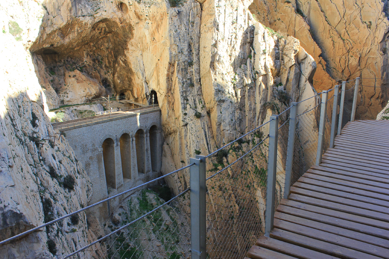
In the 2015 path the decking returns to wood, and the supports are stainless steel. The handrail is deliberately unobtrusive being three strands of stainless steel rope. A stainless steel rope has been attached to the rock as an alternative handrail.

The path clings to the upper part of the gorge where the walls are only a few metres apart. Notice in the gorge how the rock has been work away over the years by the water over the ages.
The remnants of electricity line supports can be seen all along the route. This was the auxiliary electricity for the workers facilities. Note the old ceramic insulators that were needed before wires were manufactured plastic coated.
A small set of steps descend all the way down to the river, this was to access another overflow discharge from the aqueduct.
As the gorge opens out a series of steps and ramps ina zig-zag formation decent the path down to the level of the aqueduct canal.

The path continues on boardwalk sitting on top of the old canal's outer wall. At the end a short section of canal tunnel has been prepared as part of the path including wooden decking an alternative to the narrow path that winds around a rock buttress.
You are now close to the river level, you can see oleander, tamarisk and European marram grass and you might spot otters, Spanish painted frog, common toad and Perez frog.
Looking across to the other side of the valley you can see the railway line supported on large stone structures between the tunnels. Amazing to think that this Cordoba to Malaga railway line was constructed between 1860 and 1866. It was used by all the express trains to and from Malaga until the AVE line was opened in 2007.

CASA DE GUARDIA DEL CANAL
There is a small inverted truss bridge here across the river called Puente del Rey. Next to the present path, where a lonely wooden bench sits, the old Casa de Guardia de Canal which was built under an overhang of the rock. This is where the workers who controlled the sluice-gated water flow lived. The canal widens here to form a mini reservoir to control the flow a little and an overflow drain discharges into the river, with stone steps providing workers' access down to the river. See postcard Disappointingly the casa was demolished in 2014 even though it did not appear from photos to be in bad condition.
This innovative system was the reason for the existence of the original 1901 path, which was built for workers to pass between the two sites and control the water flow through this valley. Imagine them running and shouting as they went about their job.
The Puente del Rey bridge was a way to access the railway line where a halt (small platform) used to be. Some accounts record that that King Alfonso XIII crossed the bridge here after disembarking his train on the opening day. It used to have a handrail.
A little further on after walking around a large rock buttress, and descending steps you climb a few steps leave the gorge section of the path. There is a small rest area, information board about the fauna and meeting point sign so that groups can reconvene here.
VALLE DEL HOYO
The path now follows a gentle winding route through the woods of the Valle del Hoyo. The aquaduct is always on the right hand side. The water either flowed in open canals or in tunnels.
You are entering a 'lost world', a valley whose sides are surrounded by high mountains of the Sierra de Huma and steep gorge at either end.
The reforested pine woods (Aleppo pine) offer shade and there are a number of places where you can sit and have a picnic whilst all around you will see pistacia leniscus and Anthyllis cytisoide shrubs.
There is no opportunity here, in-spite of the 200 walkers passing per hour, to buy a bottle of water. In one shady spot there is a pool to wash you face (but not drink) fed from stream water. The canal you follow has water in some places but is generally stagnant.
Notice the derelict Cortijo la Hoya and abandoned orange groves and allotments. Imagine living here.
As the railway line passes the valley with less steep sides the construction is less dramatic, there is however a large bowstring arched cast-iron truss bridge to cross a tributary.

In the next section the outer wall of the canal has broken away. A long bench in the shade offer a perfect spot to stop and rest, have a drink or a picnic. The path continues slightly away from the canal but later runs adjacent to it. The canal is covered by a stone arch in some places, presumably to stop the soil from eroding, running down the valley side, and washing into the canal. You can see the construction in one place where the roof has fallen in.
In another part where a small tributary flows across the valley side, a section of the canal has been destroyed in landslides caused by floods. The material deposited from the October 2015 floods can be seen. There are a couple of wooden seats here to rest.
The path continues with its route inside and outside the old canal. Look out for the bat shelter by the side of the path.
This section of the Caminito del Rey finishes just before the wooden steps lead us into the Balconcillo de los Gaitanes, perhaps the most exciting part of the walk. Before climbing the steps, stop for a moment to look back at the panoramic view of the Hoyo Valley.
You can see the Gaitanejo Gorge you have come through in the distance as the gap in mountains. Be grateful for the hanging path through the gorge that you used, and you did not have to climb in over the top.

Balconcillo de los Gaitanes
This is where the canal separates from the path. Notice the high iron sluice gate and winding mechanism and operator's platform to control the water flow. The canal enters a 300m long tunnel here and emerges at the famous aqueduct bridge where it crosses the gorge. It continues in tunnel behind the south cliff face to descend to the turbines of the hydroelectric station.
In a second phase of the path refurbishment this 300m tunnel with two natural openings, one at Falla Chica (the Small Fault) was cleaned, electrically lit, and opened in 2017 as an alternative path route when there are high winds. In theory it is open at any time, however it is unlikely that visitor, other than bat enthuasts, would chose this dark route. In practice it is closed off. In the heat of the summer, stand in the tunnel entrance and enjoy the cool air flowing out.
The hanging boardwalk continues around the buttress into the gorge.
A plaque commemorates Swiss Rafael Pfyffer, who fell to his death here on 14 Feb 2010, reminds us to tread carefully. "Hier an dieser Stelle bist du von uns gegangen. Wir sind dankbar, dass wir dich begleiten durften durch dein kurzes, aber sehr intensives und glückliches Leben." (Here at this point you're gone. We are grateful that we were allowed to accompany you through your short but very intense and happy life.)
From here you have a telephoto photo opportunity of the path ahead and the cantilevered viewing platform.

The path follows the cliff face inward and outwards. Next you reach the glass-floored cantilevered viewing platform yourself. It is limited to a maximum of four persons. Another great photo opportunity for the brave.
Look out for the fossils in the rocks and as you come out of Falla Chica you will see another commanding view of the Balconcillo de los Gaitanes and hanging bridge.
In the 1960 thriller "Scent of Mystery" Denholm Elliott and Peter Lorre travel across the picturesque Andalucian countryside, including the Camino del Rey, in search of an elusive American heiress (an unaccredited Elizabeth Taylor). Later they try to protect her from increasingly desperate attempts on her life. The film was one of the first to use Smell-O-Vision, a system that timed odours to points in the film's plot. The system did not work properly, even in specially equipped cinemas, and never took off. The film was renamed and re-released as "Holiday in Spain" and has a surreal quality. Without knowing the film's background story, the viewer would wonder why, for example, a loaf of bread from the oven is held in close shot for a long time.

In the next section the path follows a tributary called Falla Chica, and doubles back on itself in a sharp U-bend. The old path can be clearly seen below the new, and one section of the old path comprises a 'short-cut' option over a four-metre bridge. Over the years the handrails and toe boards have fallen away into the gorge and the old bridge deck appears to be suspended in thin air. We prefer the new path. See this bridge on a 1940s postcard.
The boardwalk continues and winds around the gorge to a north-facing slope, offering welcome shade. The ferns and acanthus or Bear's breeches like it here too, and the green backdrop and shade make for a good photo portrait opportunity.
HANGING BRIDGE

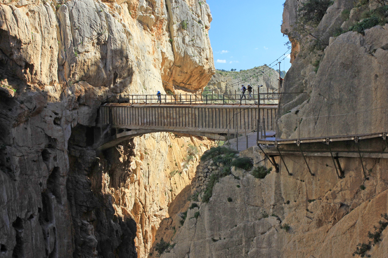
The Puente Colgante or hanging bridge is part of the modern structure - it's a 30m-long galvanized steel suspension bridge with grid decking, through which you can see down to the river 105m below. Even with horizontal stays it sways when you walk on it and oscillates or wobbles up and down. This is a great photo opportunity; a maximum of ten people are allowed on the bridge at any one time. It has been officially named Puente Ignacio Mena, after the late Estepona councilor who served on the Diputacion de Malaga.
Looking down you can see the original 1921 path (see History of the Caminito del Rey) above the aqueduct. This is called the Balconcillo de los Gaitanes, spanning the gorge; it became become one of the most emblematic images of Malaga province in its day and the modern hanging bridge does not obscure this landmark. One legend says that a pretty English girl with flowing blonde hair riding a white stallion committed suicide from this bridge.
Just before the bridge, look out for the memorial plaque to Antonio (Picholo), Andres (Moro), Martin (Loco) the three local climbers who fell to their death "Taking a giant leap to freedom" on 11 August 2000 The old zip wire that they were using came away, and has been left in place here, and you can walk under it as it hangs loosely down into the gorge. (See on Facebook)
If you are unlucky, and the wind has suddenly picked up to more than 35 km/hr you may have to wait until the wind drops or in extreme cases have to return back the start.
BOARDWALK ALONG THE SOUTH CLIFF FACE

After the hanging bridge you follow the path down some steps and out of the gorge onto the exposed southern cliff face. There is no shade at all here and in the summer afternoon the rock face seems to radiate as much absorbed heat as the sun.
This last section of boardwalk is in a chain-link cage to protect the railway line below. Cross over the railway line where breathtaking train scenes at the end of 1965 World War Two film Von Ryan's Express were filmed (2:27 to 2:59 below). In this movie you can see the German soldiers running along the Camino de Rey ( 2:58) , and the point where Ryan (Frank Sinatra) single-handedly holds back the German soldiers in the tunnel before running to join his escaped prisoner-of-war comrades on the train. (Opening to trailer below). After this filming, Frank Sinatra was arested and deported from Spain following an incident in his hotel bar; Pez Espada Torremolinos.
Southern Access Path
After leaving the Caminito del Rey via the turnstyle, notice the plaque on the rock face that commemorates the opening of the new path with the incorrect date. (See history of the path to understand why.)
Follow the path back over the railway tunnel entrance, and descend to a viewing point on wooden sleeper-edged steps. Here is the best viewpoint of the water, cliffs, boardwalk and iron railway. The path now joins an old access road.
As you walk down, the view of the Tajo de la Encantada is below and the familiar rock face of Caminito del Rey leaves your view. A grassy knoll offers a viewpoint.
The path enters the woods, read the information boards that are found on this section. The large arched railway bridge towers above you. You soon reach the El Chorro information point for the Caminito del Rey and leave your safety helmet in the box.
A tour minibus will be waiting for you here, if you are heading to the station of the shuttle bus stop, continue along the track, and on reaching the road, turn left and continua up the steep hill for a few hundred meters. There is a café and small visitors centre at the station. The shuttle bus takes you back to El Kiosko in 20 minutes. If you have paid the fare with you reservation the bus ticket will be printed on that, if not pay the driver the 1.55€ fare.
We hope you enjoy the walk.
Guided tour of Camino del Rey
Book guided tour of Camino del Rey
Book private guided tours of Camino del Rey
Excursions to El Caminito del Rey
The tours listed above have pick up points at the Caminito del Rey. For excursions picking up at other cities or resorts including the transfer to Caminito del Rey check out these listing:
Excursions from Seville,
Excursions from Malaga,
Excursions from Costa del Sol,
Excursions from Torremolinos,
Excursions from Fuengirola,
Excursions from Marbella.
Book Zip lines and Via Ferrata near Camino del Rey
back to Camino del Rey Home page


